
Decoding SPECI METAR Reports: Understanding Aviation's Rapid Weather Updates
SPECI are Special Observation reports for weather updates in aviation. Providing rapid and real-time information on changing weather conditions at Aerodromes.
There are Two Types of surface weather reports at airfields. A routine METAR and a SPECI. Which is a special report on weather conditions that’s released when one or more factors meet certain requirements. These form reports of observations are made ten minutes after visibility, weather, or cloud conditions worsen to SPECI criteria.
Aviation Weather SPECI METAR Reports - What are they?
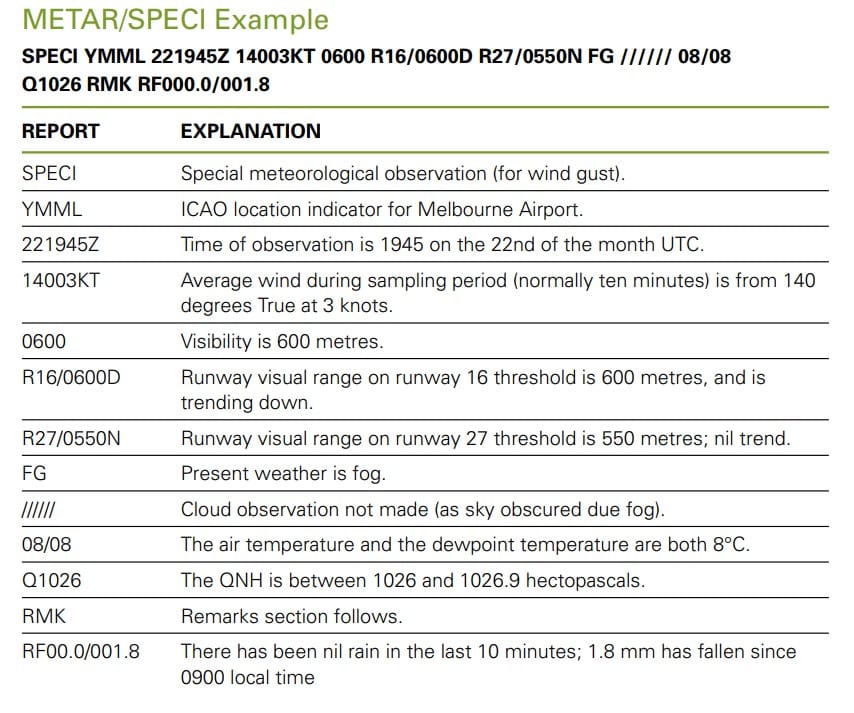
Many thanks to Australia Air Service for this excellent chart. The report that is sent/received is the BOLDED two lines of characters just under the Green writing. The Grid then explains each element. A really east way too study a real-world example. We break down each element further below.
But first, why do we need these SPECI reports?
Special Weather Report Phenomena in SPECI METAR
Reason Number One : Microbursts

Reason Number Two : Windshear
Many thanks to 3MinutesofAviation for this great clip.

Here you see the effects of Windshear on a commercial transport aircraft (B787). Now imagine this same effect on a small plane or eVTOL aircraft.
Deep Dive on SPECI METAR Reports
METAR
A METAR is a routine report of meteorological conditions at an airfield or reporting stations. So what are the routine conditions? and when do we need to break from the routine and issue a SPECI? let’s start with the routine METAR.
LOCATION
The Airport. We use the ICAO (International Civil Aviation Organization) four-letter code such as KJFK (New York JFK) or EGLL (London Heathrow).
DATE/TIME
The time of observation and the day of the month is in UTC using SIX figures followed by the letter Z (Zulu). The first two digits are the day of the month and the next four digits are the issue time and minutes. For example:
301641Z
30th of the Month. At 16:31 UTC.
AUTO
AUTO is used only when the report contains AUTOMATED observations.

pilotinstitute
Are You Ready To Take Off?
Pass the FAA Private Pilot test with flying colors. Achieve your dreams of flying an airplane.
SURFACE WINDS
Surface wind is the most critical factor in aircraft operations, period. Particularly wind shear during landing. In the SPECI, wind direction is given in true degrees rounded to the nearest 10. And its the mean value over a sampling period, normally every 10-minute period. A wind that varies is called VRB (variable). Wind speed is given in knots (KT) and is also the mean value over the sampling entire period. The max GUST during a sampling period is reported when it exceeds the mean speed by 10 knots or more. We use the letter G, followed by the gust value. At some airfields, additional wind groups will be given when wind direction varies by 60 degrees or more during the sample period.

VISIBILITY
Up to 9000 meters of vision are given, while 10 kilometers or more are indicated by the number 9999. When the visibility is estimated manually, two groups—the prevailing and the minimum—will be reported when the visibility is not the same in all directions and does not change quickly, the minimum visibility is not the prevailing visibility, and the minimum visibility is less than 1500 meters or between 1500 and 5000 meters and is less than 50% of the prevailing visibility. When this occurs, the minimal visibility will be supplied along with its direction (using one of the compass’ eight points) from the observing location.
Any variations in air or ground visibility that may exist will not be reported when visibility is provided by an automated sensor (in fully AUTOmated reporting).
RUNWAY VISUAL RANGE (RVR)
RVR will be reported from aerodromes or reporting stations with RVR instrumentation whenever the RVR or the visibility are less than 1500 meters.
WEATHER
The codes shown in the tables on the left are used to report weather phenomena. Appending: indicates the intensity of precipitation, dust, sand, and funnel clouds.
• the prefix – for light, e.g. -DZ
• the prefix + for heavy, e.g. +RA
• no prefix for moderate, e.g. SHRA
The intensity indicator for precipitation recorded with TS relates to the precipitation, for example, -TSRA = thunderstorm with light rain. One or more codes may be grouped, e.g. +TSGR, -TSRASN
AWS reports may contain details on nearby thunderstorms (VCTS) or distant lightning (DL), where nearby refers to a distance of 8–16 km from the reference point of the airfield and distant refers to a distance of more than 16 km. The notes section may additionally include information about the direction of nearby thunderstorms or distant lightning, such as DL-NE for distant lightning to the northeast and VCTS-E for nearby thunderstorms to the east.

CLOUD BASE HEIGHT
According to the following guidelines, cloud data is reported from the base to the top cloud layers:
• 1st group: the lowest layer regardless of amount.
• 2nd group: the next layer covering more than 2 oktas of the sky.
• 3rd group: the next higher layer covering more than 4 oktas of the sky.
• Extra groups: for cumulonimbus and/or towering cumulus clouds, whenever observed and not reported in any of the above
The codes in the table on the left are used to describe the amount of clouds. For example, a cloud at 700 feet is represented as 007. Cloud ceiling height is expressed as a three-figure group in hundreds of feet above the airport elevation. Only cumulonimbus and towering cumulus, such as FEW030CB and SCT045TCU, have their cloud type recognized. When a single layer is made up of towering cumulus and cumulonimbus with a shared base, the cloud is only recorded as CB.
CAVOK
The abbreviation CAVOK (Cloud And Visibility OK) is used when conditions are observed simultaneously, such as:
- Visibility is 10 kilometres or more;
• No cloud below 5000 feet or below the highest 25NM minimum sector altitude,
which-ever is the higher, and no cumulonimbus and no towering cumulus; and
• No weather of significance to aviation, i.e. none of the weather phenomena listed in
the weather table
TEMPERATURE
Rounding is done to the closest whole degree for both air temperature and dew point measurements. M (minus) is used to denote negative values before a number, as in 24/M05.
PRESSURE
The QNH value is rounded down to the next whole hectopascal and is given using four figures prefixed by Q, e.g. 999.9 is given as Q0999

TRAKRACER
Hone your aviation skills with these great flight simulator products from TrakRacer.
Get yourself in the sky today and feel what it’s like to be a pilot!
What are the SPECI Criteria?
These factors determine when a SPECI report is issued
- When Visibility and Cloud base are below predetermined levels.
- When Specific Meteorological phenomena are present (i.e. Wind Shear, Microbursts).
- When the Temperature, Pressure, or Wind vary by predetermined amounts.
Additionally, reports of observations made 10 minutes after a change in visibility, weather, or cloud cover to METAR conditions are identified using SPECI.
What are SIGMETs?
METAR and SPECI are Airport reports. As landing is by far the most critical part of aircraft operations, it is vital that pilots know what conditions to expect when they are approaching the runway. For in-flight conditions they use the SIGMET.
SIGMETs are in-flight warnings for for non-convective weather that could be dangerous for many types of aircraft. They provide weather forecasts for conditions including severe icing that isn’t related to thunderstorms, strong turbulence , dust storms or sandstorms that reduce visibility to less than three miles, and volcanic ash. Unless the SIGMET is related to a hurricane, in which case it is valid for 6 hours. SIGMETs are unscheduled forecasts that are only valid for 4 hours.
Decoding Aviation SPECI METAR Reports - Video

Incorporating SPECI METAR Data for Flight Planning and Safety
SPECI reports provide pilots with vital documentation regarding the current weather conditions at their destination. This data can be used to assess the safety of flying, while also helping to plan a safe and efficient route. By incorporating SPECI data for flight planning and safety, pilots can make informed decisions about their flights.
In order to properly use SPECI data, pilots must first understand what it is and how it is formatted. SPECI stands for Special Observation Report and contains weather observations that have been observed in the last hour or less that are not typically reported in METARs (Routine Aviation Weather Reports). These observations include significant changes in visibility, cloud cover, wind direction, temperature/dewpoint, turbulence, icing conditions and volcanic eruption.
Finally after analyzing the SPECI report and making any necessary adjustments it is important that pilots also check on airport weather conditions and along their route before takeoff. This will help ensure that any changes in the weather do not cause additional risks during the course of their flight plan. With an understanding of what is contained within a SPECI report and proper analysis techniques pilots can use this data to create safer and more efficient routes when flying with confidence knowing they’ve done all they can to ensure a safe trip!