What is a Flight Information Region?
A Flight Information Region (FIR) is a specific piece of airspace “real estate” where air traffic control is provided to all aircraft types – commercial, military and private.
Every country – and groups of countries – establish FIRs that reflect national borders or a defined geographical area.
Let’s see an example :
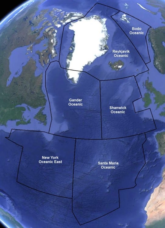
Each of these FIRs are managed by a designated Air Traffic Control Center. For example an aircraft leaving the UK to cross the Atlantic would be managed by NATS (leaving Heathrow) while in London FIR before being passed on to Shanwick FIR and then to Nav Canada when it reaches Gander Oceanic FIR.
Here’s a great video by NATS explaining the process:

Airspace that includes International Airspace is delegated by the United Nations to member states, under the guidance of The International Civil Aviation Organization (ICAO). These Flight Information Regions are mostly over water therefore have the “Oceanic” moniker. Within these FIRs lie the flight plan routes taken by thousands of aircraft daily.
Below is an example of North Atlantic routes for that traffic through the FIRs:
What does a Flight Information Region (FIR) controller provide?
Firstly there’s Air Traffic Control, the normal flight monitoring and separation you might expect from an ANSP provider. However, there’s a lot more activity in this airspace than just commercial aircraft. There’s Military operations, Private jets and even Space-bound traffic. In addition, ANSPs are also responsible for crisis management and rescue operations.
Air Navigation Service Providers (ANSPs) also provide advice and consultation mainly in the engineering field. Given their expertise in air traffic management, they are experts in issues such as 5G and sustainability. Flight/fuel efficiency and noise limitation are the key goals of the ANSP companies.
Who manages the Flight Information Service regions?
Individual airspace is managed by each country. Some join forces with neighboring countries in private partnerships. Other countries privatize their ANSPs and ATC services, such as NATS in the UK.
Top Air Navigation Service Providers are:

pilotinstitute
Are You Ready To Take Off?
Pass the FAA Private Pilot test with flying colors. Achieve your dreams of flying an airplane.
Which Air Traffic Service takes the lead in FIRs?
CANSO is the Civil Air Navigation Services Organization and is the representative body for air navigation services worldwide. Understandably, 90% of the world’s air traffic is managed by its members. We normally wouldn’t bore you with body associations however when it comes to air traffic management, we feel that joined-up thinking between ANSP’s might hold the secret for serious emissions reductions.
Aviation Risks
History and the political landscape has created a patchwork-quilt of control and authority. Flight information regions need to be integrated (and automated) so a single US gallon of kerosene is not wasted. This is happening through unnecessary routes, holding patterns or taxiing delays.
We don’t exaggerate when we say that the majority of our emission-saving goals for 2050 could be delivered by optimized route planning and control of aircraft flight routes.
The Future of Civil Aviation Operations
We need improved coordination and collaboration among stakeholders in the aviation industry. Particularly in operational matters. Firstly, interest groups, such as airports, airlines, trade unions, and air navigation service providers, have traditionally organized themselves separately to address industry-related issues. This needs to change.
2050 Aviation Programs
Thankfully, there’s been a recent shift towards closer exchanges between these groups and the European Union Aviation Safety Agency (EASA). Firstly, the importance of a unified approach in a forum called the CANSO Europe COO Forum was established.
Bringing together the Chief Operating Officers (COOs) from air navigation service providers. Key operational topics, including workforce management, trajectory-based operations, and civil-military cooperation are discussed and agreed.
The COOs identified several “game changer” topics during the meeting, including
- ATCO (air traffic control officer) Recruitment
- Workforce management,
- Trajectory-based operations
- Civil-military cooperation for fifth-generation aircraft.

The COOs have expressed a shared interest in finding common solutions to these challenges, as many ANSPs are encountering similar issues. Furthermore, the COOs held discussions with other key stakeholders like ACI Europe, A4E, IATA, and the Network Manager to establish mutual expectations and foster future collaboration.
Which are the busiest Flight Information Regions?
North Atlantic (NAT): Firstly, the largest amount of routes are crossing the Atlantic between North America and Europe. The North Atlantic FIR is the busiest region. Significant aviation traffic is handled between important hubs like New York, London, Toronto, and Paris.
Europe (EUR): The European FIR has a similarly congested airspace. Several busy airports and air traffic routes link different locations across the continent. The enormous volume of travel in this area is influenced by major hubs like London, Frankfurt, Paris, and Amsterdam.
Asia-Pacific (APAC): The Asia-Pacific region, which includes nations like China, Japan, India, and Australia, has a vast population and is seeing rapid economic development. Within this FIR, major airports like Beijing, Tokyo, Singapore, and Hong Kong handle a sizable portion of the worlds traffic.
North America (NAM): The United States and Canada, home to the busiest airports in the world, are covered by the North American FIR. Domestic flights and foreign flights to and from other continents go to the top three – ORD, JFK and LAX.
Middle East (MID): Due to its advantageous location between Europe, Africa, and Asia, the Middle East FIR sees a lot of air traffic. The crowded airspace in this region is a result of important aviation centers like Dubai, Doha, and Abu Dhabi.
Conduct of Flights over the Atlantic
Let’s study the North Atlantic. To get an idea of the complexity of FIR management. Air Traffic control of the North Atlantic FIRS involves the following countries :
Iceland
Canada
The United States
The United Kingdom,
Portugal.
Shanwick Oceanic FIR alone, which spans the Eastern Atlantic and managed by NATS, is located between latitudes 45 and 61 degrees North and extends westward to longitude 30 degrees West. As the largest FIR in Europe, it covers a sky area of 700,000 square miles. Most air traffic over the Atlantic Ocean passes through the Shanwick Oceanic FIR.
Larger Countries
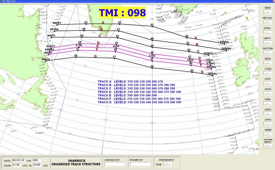
Due to the JETSTREAM (whether to avoid or benefit from it) tracks” are created for flights to follow over the Atlantic every 12 hours. Prevailing winds are considered when building these tracks, so airlines can benefit from tailwinds. Flights become more fuel-efficient as a result, and both the aircraft and the passengers reach their destinations faster.

TRAKRACER
Hone your aviation skills with these great flight simulator products from TrakRacer.
Get yourself in the sky today and feel what it’s like to be a pilot!
Air Traffic Control Services
Westbound tracks – which pass through UK airspace between 1000 and 1600 hours (hence the term Red-Eye). These are co-managed by NATS, whereas the eastbound track system is managed by Nav Canada (the Canadian ANSP).
An aircraft’s route, flight-level, speed, and expected arrival time is all controlled by the air traffic control clearances granted to pilots for crossing oceans. To ensure that aircraft entering and leaving their FIRs may be handled and controlled effectively (without overtaxing the airspace) planners on both sides of the Ocean consult with one another and coordinate as needed.
Alerting Service Providers
All routes and flight monitoring in oceanic airspace are based on latitude and longitude. Pilots – or Flight Management Computers – indicate current position, height, and the next two positions they aim to route to every ten degrees of latitude. The controller can make necessary changes or respond to requests while verifying that the airplane is rerouting in line with their clearance.
Pilot reports used to be sent via radio signal via VHF to Shannon, Ireland. But because of advancements in technology such as ADS-B over the last 10 to 15 years, almost all crews now send flight information directly to the controller from the cockpit via satellite links. Text-based messages can now be sent and received via controller-pilot data link communication systems, eliminating the need for voice reporting.

Region of Airspace and Sustainability
Advanced air traffic management technologies are being used by ATC providers to maximize airspace use, ease traffic, and eliminate aircraft holding patterns.
When possible, they work with airlines to set up more direct routes, cutting down on both flight times and fuel usage. Continuous Climb (CCO) and Continuous Descent Operations (CDO) are given first priority by ATC providers, enabling aircraft to fly along optimized vertical profiles for greater fuel economy.
Air Traffic Controllers
In general, airlines and ATC providers are collaborating to adopt novel procedures. To make use of cutting-edge technologies and optimize flight operations. To cut emissions and improve the environmental impact of air travel. For the benefit of the environment and travelers, these initiatives seek to transform the aviation sector into one that is greener and more sustainable.
HFE and VFE
Optimizing aircraft performance and lowering fuel consumption in aviation need a balance between horizontal and vertical flight efficiency. The term “horizontal flight efficiency” describes how well an aircraft’s flight-path minimizes the distance flown between two airports. It takes into account elements like route planning, air traffic control, and flight profile optimization. To reduce diversions and pointless turns, ultimately lowering fuel consumption and emissions. Vertical flight efficiency, on the other hand, focuses on enhancing the aircraft’s climb and descent profiles.
Efficient Conduct
Aircraft can reduce the time and fuel needed for ascending and descent phases. By using optimum climb rates, descent angles and continuous descent approaches. Further improving fuel efficiency and environmental sustainability in aviation operations. These efficiency upgrades are essential for lowering operating expenses, boosting sustainability, and reducing aviation’s environmental effect.
CCO and CDO
Aircraft pilots and air traffic control (ATC) use continuous climb operations and continuous descent operations as tactics to maximize the aircraft’s climbing and descent phases, respectively.
Continuous climb procedures entail a smooth, uninterrupted ascent of the aircraft to its cruising height. Instead of ascending in a series of stages with level-off intervals in between, the aircraft keeps climbing continuously as it raises its altitude. By eliminating the requirement for frequent engine power changes and level-off segments, which can cause fuel inefficiency, this helps to reduce fuel consumption and pollutants.
Air Traffic Safety
Continuous descent operations, on the other hand, concentrate on improving the aircraft’s descent phase. The aircraft continues a steady fall from its cruising altitude to the runway rather than dropping gradually with level-off phases. To maintain a smooth and continuous descending route, pilots modify the aircraft’s descent rate and speed. They may utilize gravity and natural drag forces in this way, minimizing the need for excessive engine thrust and fuel consumption. This technique enhances fuel economy while lowering emissions as the aircraft descends.
Airlines and ATC providers are implementing a number of actions to lower emissions and promote sustainability. Airlines are making investments in more recent models of fuel-efficient aircraft, such as those with cutting-edge engines and aerodynamic designs. In order to run their operations more effectively, they are also applying weight reduction strategies, improving flight planning and route selection, and utilizing cutting-edge technology.
Trajectory Based Operations - The FIR Future
Trajectory Based Operations (TBO) could be a game-changer for FIRs. It’s an air traffic management (ATM) concept aimed at improving strategic planning and reducing imbalances in aircraft flows within the current FIR regions. TBO focuses on enhancing the efficiency of aircraft movement between origin and destination airports by minimizing reactive decision-making and static miles-in-trail restrictions.

Aircraft in Flight
At the core of TBO is the aircraft trajectory. Defined in latitude, longitude, altitude, and time. This trajectory serves as a reference for the expected position and timing of an aircraft at key points along its route. It is initially defined before departure, updated as conditions evolve, and shared among stakeholders and systems. The collective set of aircraft trajectories on a given day informs traffic management actions and defines demand in the NAS.
Aviation in Airspace Managed
The key elements of TBO include :
- Time Based Management (TBM) – which schedules and meters aircraft through congested areas
- Performance Based Navigation (PBN) – which enables accurate aircraft navigation along trajectories, and
- Enabling Technologies that facilitate the sharing of trajectory information among stakeholders.
The Federal Aviation Administration (FAA) supports TBO through the integration of legacy and new automation platforms. Such as the Traffic Flow Management System, Time-based Flow Management, and Terminal Flow Data Manager.